Mt. Magalloway for 52
Submitted by Pat
Stats
Mountain: Mt. Magalloway (3,383)
Date: July 8, 2018
Miles: 2.1
Elevation Gain: 840
Trails: Coot Trail — Magalloway Spring Spur — Magalloway Overlook Path — Bobcat Trail


 The alarm clock buzzes me groggily awake at 4:00 am. I feel lousy, dehydrated, with a sour stomach and a thick head…all because I had a third beer last night. Yes, I’m drinking again, after over ten years of sobriety. I am disappointed in myself. I worked hard to quit back in 2006 and staying there has been easy. The slide down this new slope happened slowly and insidiously and now I have been drinking for over a year. No need to dive into the mental and emotional machinations I have gone through to justify this return – they sound like a broken record anyway – just the meanderings of an alcoholic. What I know when I wake up feeling lousy on Sunday morning is that quitting has to come sooner than later. I’ve known that for a while and have been procrastinating, having finally decided to stop after my two-week vacation on Martha’s Vineyard in September. But maybe sooner is a smarter option.
I’m not drinking to fill a void in my life. I’m not drinking because I’m depressed. I’m not drinking to self-medicate. I’m drinking because I love the taste and I like the buzz. I like the edge it takes off the tension and anxiety with which I live. As I write this, the reasons I drink feel so direct and simple, so clear and uncompromising. And yet I know they are the justifications of an addict and quitting is the only path back to self-respect. So that’s where I am as I sit in the dark at my kitchen table, sipping coffee in anticipation of seeing Nancy after her month visiting her grandchildren in Colorado and the long drive into the north country to finish the 52 with a View list on Mount Magalloway.
The drive to the MacDonald’s parking lot in Lincoln passes with me drinking a lot of water and trying not to think about my burning stomach and aching head. Seeing Nancy and giving her a hug helps my low mood but I can feel rumblings in my lower intestines and excuse myself to the MacDonald’s restroom for a bout of diarrhea. Good timing to flush the poison from my system. We move her gear into the back of my Rav4 with over 262,000 miles on it (most of those miles from driving to the White Mountains starting in 2006 when I bought it) and head up I93 to Rte. 3 and Munroe’s Family Restaurant in Twin Mountain. They are just opening so we have our choice of seating and eat a delicious breakfast with real home fries.
 The comfort and ease with which Nancy and I reconnect on the drive north is refreshing, even when I admit to being slightly hungover. Again, we talk more about my drinking and quitting. She never judges but would love to see me stop. Our communication is a wonderful blend of give and take, as she shares her experiences hiking and living in Colorado with her daughters and grandchildren in June, and I share my struggle with alcohol and enjoyment of summer, my gardens, and work. The day is gorgeous and we remember climbing the Percys and Sugarloaf as we pass through Groveton, NH.
The turn onto the logging road is clearly signed as Mt Magalloway Rd so there is no anxiety about whether it’s the right turn. The first five miles of road are well maintained. We rumble along, throwing a long spume of dust behind us. We turn off on the side road marked Tower and the road quality deteriorates, slowing us down to 10-15 mph. Glad for the Rav’s high clearance, we slowly drive the last three miles to the trailhead. We are both surprised when we see three cars parked in the small turnaround. What we miss seeing about 50 feet before the parking area is a trail sign for the Bobcat Trail. All we see is the Coot Trail. I thought the two trails shared the beginning and then split, but I guess I’m wrong.
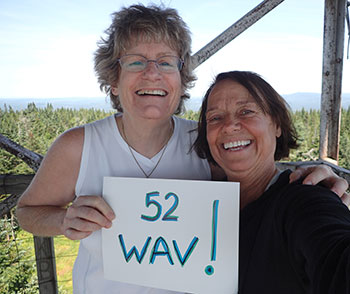
After gearing up, we head out onto the wet Coot Trail. It’s a wide trail, obviously used by snowmobiles in the winter, but is still rocky and very steep. Even though we are shaded by trees most of the way up, the warmth of the day and the steep trail sets us both streaming with sweat. It feels good, despite the fact that I am not feeling my best and have not exercised much since my solo hike up the Dry River Trail on June 30th. Roots, rocks, erosion, and deer flies accompany us to the top of the ridge. Shortly afterward we come to the “top” where we encounter three other hiking groups. Nancy made a sign and we ask some folks to take our picture which they gladly do.
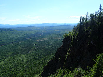
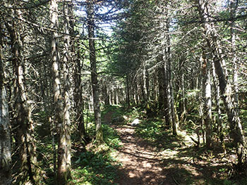 We climb up to the top of the fire tower where the wind and temperature difference is amazing. Brrr… We take some photos and head back down. We check out the spur trail to the outlooks, take more pictures, but the deer flies make stopping to eat impossible. We head back down and see the turnoff for the Bobcat Trail and take that. What a pretty trail! It follows a ridge, the trail surface covered in pine duff, and is less steep than the Coot trail. There are a couple of blow downs. One is seriously blocking the trail and I start off following a herd path to the right since climbing over the debris looks like the worse of the two options. We bushwhack for a while then the herd path peters out and we are no closer to the trail so we head back and carefully climb over tree trunk and branches to the trail on the other side. We hear the family group we met a the top hiking behind us approaching the blow down and offer our help with the toddler who is hiking in her own backpack on her father’s back.
After that we are down in no time. We eat our lunches in the car then head back down the state toward Nancy’s car in the MacDonald’s parking lot in Lincoln. We talk a lot about our next project and my enthusiasm for the White Mountain Guide red-lining challenge wins Nancy over. I have done some work updating our previously traveled trails on the 30th edition spreadsheet. I’m excited about sending it to her and beginning a new phase in our hiking journey. I am thrilled to have all these new, (and old) incredible trails to explore.
On to the next goal!