Katahdin: The Beginning
– Baxter Peak
Submitted by Pat. Nancy’s comments in italics.
Stats
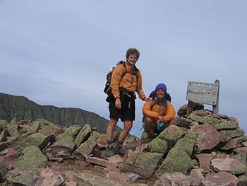
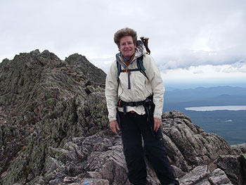
Mountains: Pamola (4,919) and Baxter (5,267) Peaks
Date: August 10, 2006
Time: 11 hours and 52 minutes
Miles: 10.42
Elevation Gain: 4,883
Trails: Helon Taylor Trail — Knife Edge — Saddle Trail — Chimney Pond Trail
Holy Shit Factor: very high


 In the beginning there was Katahdin. That’s what started it all. We wanted to climb Katahdin — the highest mountain in Maine. To get ready, we figured we’d better climb a few peaks first, just to make sure we could do it. Seventeen peaks later, with a new goal of climbing all the 4,000 footers in New England, we arrive in Millinocket, Maine, fit and psyched.
We log onto the internet Wednesday night to check weather…again. For Thursday, 30% chance of morning showers and chance of thunderstorms in the afternoon as a cold front passed through the area. Friday, our fall back day, also showed a 30% chance of showers. We decide to go on Thursday with the attitude that the experience will be what it will be. Asleep by 9 p.m.
Up at 4:00 am in the dark and first at the park gate at 4:45 am. (Okay, folks. This is crazy! Is it really the best plan to make hikers get up at 4:00 am to be in line at the gate by 4:30 am, so they can get into Baxter State Park at 5:00 am to secure a parking spot in order to hike? Really?) The gate opens at 5:00 am, and we check in, pay our fee to a grumpy Ranger who doesn’t bother giving us a weather report, a safety speech or telling us it is a Class II hiking day (when park officials suggest NOT going above tree line). We reach the Roaring Brook Campground parking area, finish packing our gear, and set out on a new adventure at 5:46 am. The cloud deck is high and we keep our fingers crossed that the weather will hold.
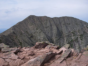 I had chosen the trails based on maximum views as well as challenge. At least for the first part of the morning, we have both. Once above tree line, the expanse of rock is astounding. It looks like someone has tossed sharp granite rocks into a humongous heap and then carve out a circle in the middle of it, leaving jagged rocky edges reaching to the sky in a semi-circle around the rugged remote wilderness at the foot of the mountains. The wind picks up but the clouds stay high and generally dry, although we stop to put on and take off rain gear a couple of times. The first view of the ridge up to the Pamola summit is awe-inspiring. (Yes, AND it was REALLY far away! Holy Shit! A group of young men who had passed us earlier were half-way to the summit and they looked like ants. OK we can do this!) Up and up and up we trudge, reaching the summit of Pamola (elevation: 4919 feet) at 9:34 am.
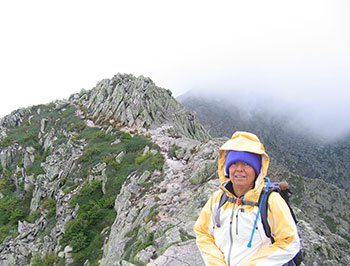
When we look ahead at the Knife Edge, I feel a mixture of excitement and trepidation — excitement because it is just so big and stark and wonderful and trepidation because it is so big and stark and wonderful. I had looked at a lot of pictures of Knife Edge and read a lot of trip reports and descriptions, so I am somewhat prepared for what I am looking at, but seeing it in the flesh, with the wind whipping up to 30-mph and knowing the weather is going to deteriorate is both incredible and intimidating. (I had NOT done a lot of research and pictured in my mind Knife Edge to be a ridge similar to the Franconia Ridge Trail connecting Little Haystack, Lincoln and Lafayette, just a bit more narrow. WRONG! It was a line of gargantuan, perilous, black shark’s teeth, daunting in size, dismal in cloud cover, waiting to eat us whole. With a 2,000 foot vertical drop off either side of the narrow rocky ridge — a solid mile of exposed, torturous and dangerous scrambling — and the wind whipping around us, it seemed perhaps to be quite perilous. If the Knife Edge shark didn’t devour us, we’d be blown off the mountain anyway. I quickly shifted from saying Holy SHIT to Holy FUCK.)
We are transfixed by the first two chimneys on Knife Edge. (Okay folks — Pat was transfixed. I was scared shitless! As we started down the first chimney, we saw the group of young men working their way up the other side of the next chimney. A strong, strapping, tall young man looked at his friend below him with a mixture of fear and dread because he saw no way of getting up to the next ledge. He couldn’t reach it with a foot and had no hand holds to pull himself up. His friend pointed to a place on the sheer rock face and guided his friend’s foot to what looked like a minuscule foot hold, hoping that would give him the leverage he needed. Holy FUCK! I was in serious trouble!)
Climbing down the first pitch (Class IV?) gives me a real sense of what we are in for, although it looks like once we pass the two chimneys we will be on a more serrated, yet level ridge. I climb down backward, relying on my strength to hold my body in place until I find purchase for my feet. Nancy climbs down facing forward, needing to see where she is going. I can’t climb down forward. Period. We help each other, either by pointing out the best foot holds or speaking words of encouragement. I am scared — more of going down than of going up — but more exhilarated than anything. I can tell Nancy is out of her comfort zone. Being short, it is hard for her to reach the best hand or foot holds, so I offer to help. Nancy is a strong, self-reliant person, so it is difficult for her to accept help, especially since she feels she isn’t reciprocating. Little does she know that her encouragement and even her fear diminishes my anxiety and I feel strong as we climb up the headwall of the next chimney.
 After conquering those two climbs, we look ahead across the Knife Edge and see clouds streaming over the edge. That is the end of views and any kind of warmth from the sun. The temps fall into the 40s and the wind picks up (Great!). Every so often, the wind gusts so hard we have to stop moving and grab hold of the coarse cutting stone to keep our balance. We can just barely make out the young men ahead of us, crawling up into the clouds. (Where the hell were they going and how far up did it go? Oh God!) On we go, visibility reduced to 10-20 feet with an occasional glimpse of the next rise ahead of us. Scrambling on these granite boulders is challenging. We summit South Baxter Peak (elevation 5260 feet), but have no idea where it is, except in the clouds. During the entire 1.1 miles, I rarely take two level steps in a row. It is a constant fight for balance. We run into a group heading in the opposite direction and one of the men says to us, “I’d be lying if I said you were more than half-way across!” We look at each other, share a rueful grin, and move on. My impulse as we walk is to seek human contact amid the foggy desolation of the ridge while Nancy experiences the opposite — she wants to pull away and steel herself for the next maneuver. It is a moving experience for me to ask Nancy for a hug and it is a humbling yet rewarding experience for Nancy to willingly accept my help. Both of us are out of our emotional comfort zones. (We were different people climbing Katahdin than when we first started peak bagging. We are a team, relying on each other. Hiking has helped us both grow, physically and emotionally. Wow — who would have thought?)
(Okay you guys — think about this. Navigating the Knife Edge took us 2 hours and 10 minutes. It is ONLY 1.1 mile. One point one MILE! You can walk a mile, going heel to toe to heel, touching one to the other, each and every step, in a little over an hour. We know, we timed ourselves as a test. Knife Edge took us two times as long! Negotiating our way over a mile of shark’s teeth, rubbing our hands raw by grabbing gritty rock to save our lives, using our knees when we couldn’t reach with a foot — it was the longest mile we have ever seen.)
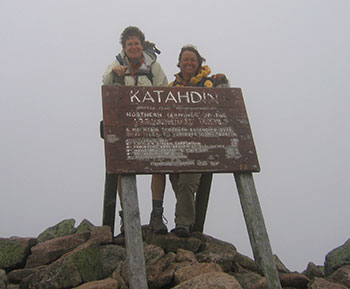
We reach the Baxter Peak summit (elevation 5,267 feet) at 11:45 am. We find a spot out of the wind and eat our chicken salad sandwiches. Yum.
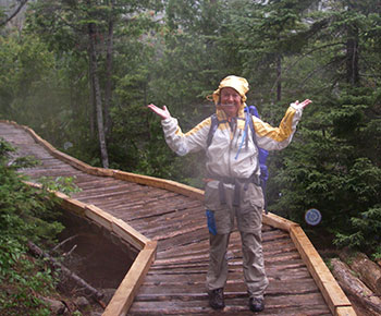
Nancy starts to get very cold so she puts on another layer (Yes, that’s right another layer. By now I had on a sleeveless tech-wick, a long sleeved tech-wick, a fleece, a windbreaker, Pat’s wind breaker and a fleece hat!) We start across the Tableland toward the Saddle Trail at 12:22 p.m. As soon as we start moving, the rain begins, making the footing even more treacherous. At first it feels like hail — the wind is whipping the drops so hard. We finally realize the rain is not going to stop, so we put on full rain gear and pack covers and continue on. Just before reaching the top of the Saddle Trail, hot from our effort, we take off our rain pants and continue our descent. The rocks are very slick and the entire first half mile is a rock slide. We stay to the far left holding onto rocks as we slowly lower ourselves down the headwall. It takes forever. I have a bit of a slip that knocks some fear back into me on the way down. I mash my toe but I am fine — no blood drawn.
We are pretty fatigued when we reach the tree line. (I was pooped. Climbing Katahdin was one of the hardest things I have ever done!) Coming into the Chimney Pond camp area is a welcome respite. Nancy is out of water so she asks the ranger if there is a supply of potable water nearby. He is very removed and unfriendly in his response. He could have said, “Hi – how are you all? What trail did you come down? How has your day been?” Instead he just says he has no purified water and goes back to his paperwork. I have a liter of water left so we split it and as we gear up for the last 3.3 miles, the rain starts coming down in earnest. In retrospect, we should have put on full rain gear, but we only put on the top half — she in pants and me in shorts — and head down the Chimney Pond Trail at 3:22 pm.
Lesson learned: Weather makes a big difference.
Those last 3.3 miles are long, long, long — did I say long? Wet…and long. By the second mile we are feeling pretty tired and a bit slap-happy.
 “Hey I’m loving this rain — feels so cold and clammy,” one of us said with sheer glee.
“Meeee too!” the other chimes in. “And don’t you just love that twinge in your knees every step down you take. And it’s great when you have to go sideways to prevent your knee from folding in on itself. It feels sooo good!” said with sincere sarcastic happiness.
“Yeah — and guess what? I have to peee and it’s raining even harder! Wowsers — it feels so good to pee in the pouring rain and get my bare butt totally soaked! Awesome!”
“Wow, sure hope this trail never ends, this is just too much fun!”
Quite a few groups of people pass us during this time. They look like a sad, soggy lot, especially those in cotton with no rain gear. We, on the other hand were having a great time, laughing our heads off.
“Yippeeeee! Yahooo! Whoooo Hooooo! Sure hope the rain doesn’t let up — I’m loving these huge puddles!”
And on it goes, humor instilling hope, sustaining us till we reach the trailhead and our car at 5:36 pm.
Lesson learned: Humor helps.
It is a great relief to get out of our soaking clothes and put on relatively dry rain pants, get in the car, and crank up the heat. The 8-mile drive out to the gate is interminable and the 25-mile drive back to Millinocket feels so incredibly long, we can’t believe it.
Back at the KeepRidge Inn, our weary wet bodies cold from the inside out, there is one awesome saving grace. We dump filthy wet clothes, boots and packs on the bathroom floor, change into bathing suits and run for the hot tub. Aaaahhhhh…. Bliss. We survive. Whoo Hooo!!!!!!!!!!!!!!