Mts. Galehead and Garfield
Submitted by Pat
Stats
Mountains: Mts. Galehead (4,024) and Garfield (4,500)
Date: June 21, 2006
Time: 10 hours
Miles: 13.7
Elevation Gain: 3,848
Trails: Gale River Trail — Garfield Ridge Trail — Garfield Trail
Holy Shit Factor: moderate


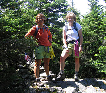 Wednesday is the best weather day of the week so Nancy and I take a day off from work and head to the White Mountains to bag a couple more peaks. This time we choose to tackle Mts. Galehead and Garfield: our 7th and 8th 4,000-footers in New England. We reach the trailhead parking area, change into boots, put on bug dope, haul on our packs, and hit the Gale River Trail at 8:41 am. The Gale River Trail is a long, but civilized trail up to the Galehead Hut. We cross the river a couple of times, once taking our boots off — cold and refreshing. Nancy and I are in good spirits, feeling strong and ready for the 13.9 mile loop. The woods are dark and green, the trail muddy in some areas. In fact, a mile or so into the hike, I fall… hard — I think I am stepping on a rock but it turns out to be a log and my foot slips off into a foot of mud while I slam into the trail on my right side. Couple of bruises and a cut on my elbow — nothing to see here.
We hear oven birds, yellow warblers, winter wrens, a veery, and some wood thrushes. I love the sounds in the woods. As I walk, my senses are so open — I absorb sounds and smells like they are nutrients, balm for the soul.
We arrive at the Galehead Hut at 11:15 am, wondering at the bizarre whirring sound made by the windmill thingie on top of the hut. Not sure of its purpose…electricity? But it makes a weird, unnatural sound when the wind gusts. This is our second visit to an AMC hut (Greenleaf hut was the first). We meet up with a couple of friends who hiked up the day before and they join us as we hike up to the Galehead summit, then back down to an overlook to eat lunch. After lunch we hike back to the hut, our friends pack their gear, and we head down the Garfield Ridge Trail at 12:41 pm.
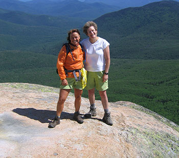 Down, down, down, down we go. I had read that this is supposed to be a ridge with minor elevation change. Wrong. I like the trail, but when Garfield pokes its head above the trees and we actually get a sense of how much elevation we are going to have to regain, I can hardly believe it. Perspective is so different when I’m climbing. I look at where we’ve come from or where we’re going and sometimes think to myself, “I can’t do that — it’s way too long,” and sometimes think, “Wow, we hiked all that way in just an hour!” I begin to feel a little fatigued so looking up at Garfield is a daunting. Truthfully, though, I love hiking on trails that are straight up with lots of scrambling — like the Flume Slide Trail. So up we go and arrive at the summit at 3:11 pm. We have a beautiful view of the Pemigewasset Valley and Owls Head. A true 360 view. Gorgeous. But the black flies are incessant and annoying, despite the breeze and cooler temperatures at the summit. After taking pictures, eating something, and changing my socks, we start back down and arrive at the Garfield Trail intersection at 3:41 pm.
Our friends are much faster on the descent (and the ascent as well) so Nancy and I hike alone like we usually do. They had stashed their bikes at the trailhead and are going to ride the 1.6 miles to the Gale River trailhead to get both our cars. What service! We start down an easy grade. I use my poles because I know how painful my knees can get on descents. Again, a very lush, green trail, with some muddy spots and areas where the trail is rock free and I can raise my eyes from my feet. I don’t like always having to watch where I put my feet — I miss seeing things in the woods around me. But at this point in the hike, I am tired and if I don’t watch my feet, I make mistakes and several times almost do a face plant on a rock face. So, I watch where I put my feet, especially since I’m tired.
The trail is about 4.9 miles long, making for a pretty long day, and as we walk, it feels like it is never going to end. After three miles or so, I keep expecting to see the parking lot around every corner, on every horizon, but no, the trail ends when it’s good and ready, and I am soooo happy to see our friends driving up with the car. We hit the parking lot at 6:21 pm: 44,833 steps according to my pedometer and our feet feel every one of them. It feels so good to put on Tevas and head to Gordi’s in Lincoln for a burger. I need to replenish my body with protein and carbs. Yum. We sit in the sun and talk about how great it is to celebrate the summer solstice by spending it bagging a couple of peaks.